Abstract
The paper presents the results of an archaeological survey of the the Aegean region, which combined systematic pedestrian and underwater survey with extensive use of remote sensing techniques (including satellite imaging and ground penetrating radar) to document patterns of human activity in the coastal zones during the Middle Athropocene era (late 2nd to early 3rd millennium AD). The authors also refer to contemporary documentary, epigraphic and iconographic evidence in order to reconstruct the social and historical context of the survey findings. It is argued that the spatio-temporal patterning of the findings represents cycles of politico-religious activity in which the power of “being” was embodied in the sacred landscape. Ultimately, the cycles of creation and destruction, the appropriation and de-appropriation of land and resources represented in these usage patterns inscribe on the landscape the contestation of public and private spaces characteristic of a “weak” polity struggling to establish public rights over the assertion of private “wants”.
The survey findings
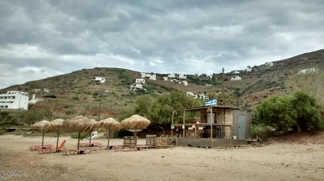
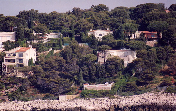
Our survey has documented a range of structures and material evidence relating to the human occupation of the coastal zones of the Aegean basin during the Middle Anthropocene (late 2nd-early 3rd millennium AD). We divide these structures into two broad types and posit different, specialised uses for each. Type 1, which will be the focus of this study, consists of structures of perishable natural materials found in close proximity to the ancient coastline. Type 2 are more permanent structures, predominantly of reinforced concrete, sometimes found on the coast, but also further inland. Elsewhere we have demonstrated that this latter type structures exhibit the full range of domestic activities, and can therefore be safely described as habitations. We will therefore concentrate on the former, more enigmatic structures.
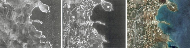
We used a combination of underwater exploration and surface survey to conduct a detailed examination of a number of Type 1 structures and collect materials for study. The configuration of the coast changed dramatically over the period covered in this study, as glacial melt due to anthropogenic climate change caused sea levels to rise in excess of 1 metre over a period of 100 years in the early 3rd millennium, and shorelines to retreat between by about 400 and 6,500 metres. The inundation of the coastal zone had beneficial effects for the preservation of organic construction materials (primarily wood and reeds), which has enabled us to reconstruct Type 1 structures in some detail.
Through a combination of satellite imaging techniques we have been able to document and date quite precisely the evolution of the coastal landscape, which shows an accelerating pattern of infill in the latter part 20th century AD and into the 21st century.
In the case of Type 1 structures specifically, our excavations have been able to determine that their usage was strictly seasonal, with pollen analysis showing that they were in use almost exclusively in the summer months. Moreover, artefact-rich layers are often interspersed with barren sandy strata and burnt horizons. The stratigraphic record thus shows a longer term cycle of what appears to be deliberate destruction (razing) by mechanical means and sometimes burning, followed by periods of abandonment and reconstruction. We attempt to explain the significance of this pattern in conjunction with epigraphic evidence at the end of the paper.
Material culture

By far the most common find associated with Type 1 structures is the “domed kylix“, a lightweight drinking vessel with a domed protective cover bearing an aperture for a drinking kalamaki (straw), based upon the high percentage of domed kylikes found containing complete or partial kalamaki. Residue analysis of the interior of the kylikes revealed in most cases traces of the berry of the plant Coffea arabica, a shrub native to the Arabian peninsula, known for its mild stimulant properties. The use of the cup suggests that it was imbibed in liquid form, while the straw is reminiscent of the earliest Mesopotamian depictions of beer drinking, suggesting that the drink was surmounted by a foamy “head”. The purpose of the protective dome is unclear due to the varied and often disturbed contexts within which the kylikes have been found; intriguingly many such domed kylikes are found in stratigraphic association with carbonised Nicotiana tabacum (see discussion infra); it is possible that the dome may have been intended to keep ash from settling in the liquid (sacramental beverage?) contained within the kylix; insufficient evidence exists to render this supposition conclusive.
The cups themselves commonly bear a manufacturer’s stamp on the base with the legend “Made in China”. Samples of the sandy earth which typically surrounds the structures show a high content of ash, also containing carbonised remains of the leaves of the plant Nicotiana tabacum, native to the Americas. This also a mild psychotropic, and it is believed to have been consumed by inhalation. This evidence attests to a far-flung trading network, bringing exotic substances and consumption habits to the users of these seasonally utilised structures. It is notable that the seasonal users do not appear to have made use of any of the marine resources available within the catchment area, but instead plastic food packaging was found in abundance, suggesting that they were entirely dependent on imported, high-value, processed foodstuffs.
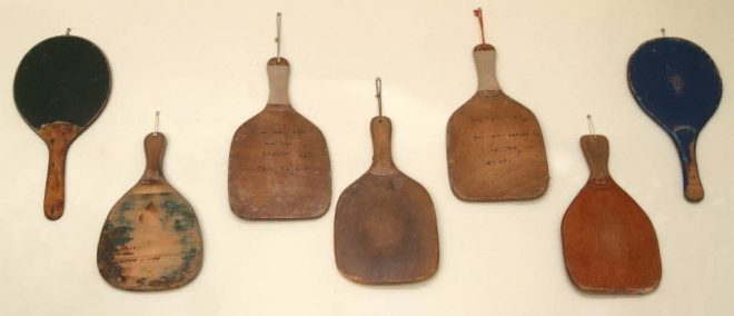
Another artefact type commonly associated with the Type 1 structure is the wooden maniform pallet. Similar in form to a pizzaiolo dough paddle, their small size and the absence of association with fournoi suggests that the pallets were deployed for some purpose other than panifacture. Often found in matching pairs and with distinctive wear patterns in the centre, the use of the paddles is unknown, and many scholars have suggested that they fulfilled a ritual function.
Interpretation
As students of this period are well aware, the contemporary documentary record is fragmentary. Although this was a society characterised by a high degree of literacy, records were preserved overwhelmingly in digital form, and were therefore largely erased by the Great Solar Storms of the mid-3rd millennium AD. We therefore rely heavily on the epigraphic and iconographic record.
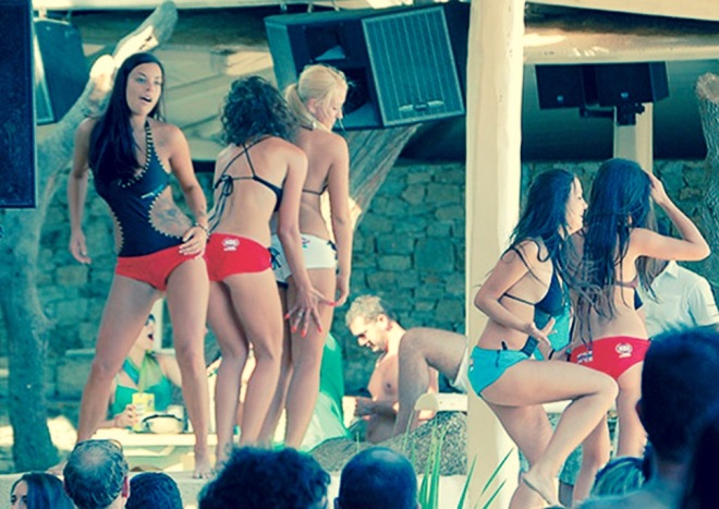
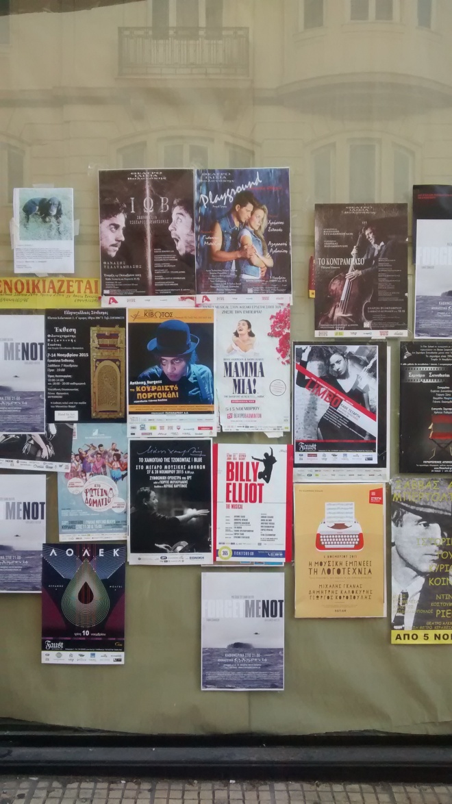
A group of photographic images preserved on paper are thought to show events taking place at Type 1 structures, the best known of which is the so-called “Mykonos fragment” shown above. The photographs show crowds of predominantly young people of both sexes engaged in what appears to be an ecstatic ritual, often led by lightly clad priestesses (or anthropomorphic deities?) shown here dancing on an elevated platform.
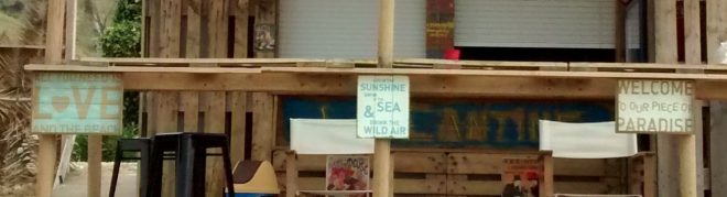
Epigraphic evidence from the sites themselves comes primarily in the form of painted plaques, which support the idea that Type 1 structures were associated with rituals of a seasonal nature. The text contains brief exhortations (“LOVE”, “RELAX”, “ENJOY”) inviting celebrants to situate themselves outside the routine of secular life (in a state of “ecstasy”, from the Greek ek+stasis, stand outside), while others seem to promise rewards in the form of a mystical afterlife (“WELCOME TO OUR PIECE OF PARADISE”).
It is tempting to link these structures to fragmentary epigraphic evidence surviving from the time. A votive envelope typical of the period, uncovered in a religious/administrative complex in the Middle Anthropocene phase of the city of Thebes, contained a bundle of Euro notes, accompanied by fragments of paperwork bearing the heading “TAKT[O]ΠΟΙ[Σ]Η ΑΥΘΑΙ[ΡΕ]ΤΟΥ” (translated as “Regularisation of Unlicensed [Construction]”). Such finds have been interpreted as offerings made with the intention of regularising (i.e. preserving) an irregular structure such as those documented here. Collectively, they suggest a preoccupation on the part of the keepers of Type 1 and Type 2 structures with safeguarding private ownership and attesting to the legality of their activities within the official religious-administrative apparatus. It suggests that the boundaries between public and private land, and the right to build on it, were fluid and open to ongoing contestation, requiring repeated appeasement of the deities (authorities) on the part of their claimants. This ties in well with the stratigraphic evidence showing cycles of destruction and rebuilding (death and rebirth?), which can perhaps be seen as the physical manifestation of this contestation.
This provides an illuminating counterpoint to what we know about the society of this period, and suggests that the archaeological record can evidence an alternative “being”, or “practice” in Bourdieu’s sense, which challenges the “official” ideations of the relationship between space and power. We commonly think of the Greek polity of the period as being a highly centralised state society (“hydrocephalous” to use the terminology of some scholars). We know, for example that the Greek state was centrally administered by a powerful priestly caste, which at times comprised almost a quarter of the working population. This caste, defined by ties of real or fictive kinship, was able to mobilise and redistribute resources through a complex network of formal and informal exchange systems. This highly structured, centralised system of control contrasts sharply with the material record revealed through archaeological inquiry, which shows greater instability, a fluidity of public and private ownership, uncertainty and insecurity within the population, and ultimately evidence of a weak central state effectively contested by private “wants”.
Further Reading
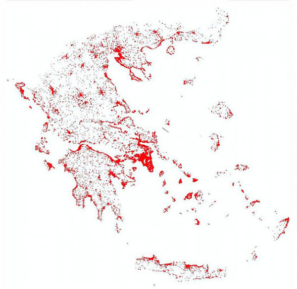
As of the early 21st century AD, building on forest land and the coastal zone are prohibited by the Greek constitution, however in practice they are systematically built on illegally. Beach bars (“Type 1 structures”) and seaside tavernas are a particularly visible form of encroachment, and holiday homes in forested areas (“Type 2 structures”) are another. Repeated “regularisation” (amnesty) programmes by government and a record of selective political intervention aimed at cultivating a local client base, have tacitly encouraged this illegal building activity, while official land designations (like forestry maps) are regularly contested, either through legal challenges and legislative amendments, or by illegal activities such as building and burning, or encroachment by grazing.
Historical reviews and selected statistics on these subjects can be found (in Greek) here and here. The first linked article quotes an account by a popular Greek composer of a visit in the 1960s to then Prime Minister Georgios Papandreou (the Elder) to discuss an application by a group of artists to build a residential community in a forested area outside Athens; in the account Papandreou hugs them, picks up the phone to the Agriculture Minister and instructs him to get the area zoned for building within a month. The community (“Καλλιτεχνουπολη”) now even has an official sign on the highway. The latter article notes that in 2001, the Municipality of Keratea in East Attica recorded 6,000 illegally built homes compared to 8,500 legal ones.
A newspaper article from last year (also in Greek) describes vividly the political interventions which prevented the enforcement of land zoning in Attica. When the demolition crews arrived to take down illegal homes which had been standing for 30 years and were declared illegal by the courts as far back as 1994, the local MP led emotional demonstrations by residents, the Interior Minister personally intervened to halt the demolition, and the regional authority warned that any more scheduled demolitions would be met by further public demonstrations. In other instances, MPs of all parties tabled amendments to legislation in order to prevent scheduled demolitions in their constituencies, one even legalising a number illegal cemeteries (another form of encroachment).
In recent years, central government has repeatedly overriden the rulings of the constitutional court intended to protect the coastal zones, including those included in the European Natura 2000 programme, by allowing municipalities to set up beachside facilities. Under the most recent legislative amendment, these facilities have been exempted from inspection, raising concerns for protected wildlife species and sensitive ecosystems.
Buried in a 7,500 page emergency omnibus bill of measures linked to completing the latest bailout review is a seemingly unrelated amendment which environmental group WWF warns could further undermine the current land classification scheme and result in the legalisation of large swathes of illegal build. [POSTSCRIPT: This amendment was removed from the final bill following criticism (according to Skai TV Eco News, 28 May 2016; however, the new law leaves considerable uncertainty around the status of forest maps, allowing plenty of potential for future abuse].
As an additional complication, Greece still lacks a comprehensive land registry and zoning map (cadastre) which makes it hard to establish ownership, particularly in rural areas.
DISCLAIMER: The absence of several pages of citations will have alerted you to the fact that this is not a genuine academic article. The final section is factual, and hyperlinks throughout lead to genuine sources.